
You are about to action:
Object being modified by the action
Do you want to proceed?
If you wish to action:
Object being modified by the action
Then please send an email request to [email protected].


When I visit state forests and parks, I do so randomly, without any intention in mind other than to capture footage of it's environment at that moment, on that day, from a closer proximity to the ground. As I did when I decided that day to visit Douglas State Forest, north of Rt 16. I was unpleasantly surprised to discover that the small areas I decided earlier to enter and document, were rather dull and lifeless. The sounds of nature were almost non-existent as the sound of road traffic from Rt 16 sometimes dominated the experience. I answered that challenge by lowering the volume of that noise and providing music throughout the video. And then, at the second entrance I made farther east on Rt 16, I was informed by a sign that hunting occurs there throughout the year. I suppose that explains why I heard no wildlife.
I could tell you accurately how large Douglas State Forest is, if only websites about it agreed. The state government website states the acreage of the state forest covers 5,907 acres. Another website about state parks and forests describes it as 4,640 acres in size. The Verdant Traveler website describes it as 6,282 acres in size. But one thing is known for sure. The drab and lackluster section of the forest I visited does not represent the entirety of the forest. Because it appears that farther north into the forest, and south of Rt 16, the forest offers much more in recreation and scenery than what I saw.
The Long Dark by Scott Buckley | https://soundcloud.com/scottbuckley
Music promoted by https://www.free-stock-music.com
Creative Commons / Attribution 4.0 International (CC BY 4.0)
https://creativecommons.org/licenses/by/4.0/
References:
State of Massachusetts - Douglas State Forest
https://www.mass.gov/locations/douglas-state-forest
Massachusetts State Parks
https://www.stateparks.com/douglass_state_forest_in_massachusetts.html
Verdant Traveler
https://verdanttraveler.com/douglas-state-forest/
Map by Bing Maps
Other Graffiti Forensics channels and pages
https://rumble.com/c/c-1218693
http://www.youtube.com/c/GraffitiForensics
https://www.facebook.com/GForensics/

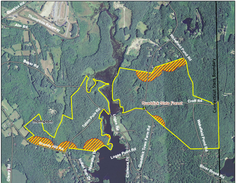
This was one of those perfect days for visiting a state forest. Not only is the small area of Quaddick State Forest that I visited free from the noise of nearby traffic, it offers the sounds of bird species which can be heard in the background of the video. A species I can't identify. If you know what that is, let me know in the comments. Outside of that, the sound of a family who was nearby enjoying the natural environment can be heard. In one segment, it almost sounds like a child is responding to the bird I kept hearing and I ask about here.
I entered the west side of the state forest off of Baker Rd, using what appeared to be a trail that has it posted vehicles are not allowed. This is marked on the map as Totem Pole Rd. It would have to be what I guess is OLD Totem Pole Rd, because there is another residential Totem Pole Rd in the vicinity farther south, on the shoreline of the Quaddick Reservoir. While you can't see this on the map I provide in the video, 'Any Place America' provides a map of the area that does show the residential Totem Pole Rd on the shoreline. But you'll have to zoom in to see it labeled as such. It appears to be a short, dead end road. Another map published by ExploreCT will show you the boundaries of the state forest (see the links in the description).
According to Connecticut's Department of Energy & Environmental Protection, Quaddick State Forest contains approximately 550 acres. "The forest is located both on the east and west sides of the Quaddick Reservoir, an industrial reservoir covering approximately 466 acres. The original parcel was acquired by the Resettlement Administration of the United States government and leased to the State back in the 1930s. The forest protects the reservoir while also providing ample recreational activities. This includes fishing for bass and pike; hunting for deer, turkey, and small game; canoeing and kayaking opportunities; and youth group camping."
Friends Forever by FSM Team feat. Dvideoguy | https://www.free-stock-music.com/artist.fsm-team.html
Music promoted by https://www.free-stock-music.com
Attribution 4.0 International (CC BY 4.0)
https://creativecommons.org/licenses/by/4.0/
References:
Any Place America - Quaddick State Forest
https://www.anyplaceamerica.com/directory/ct/windham-county-09015/forests/quaddick-state-forest-210033/
ExploreCT - Quaddick State Forest map
https://explorect.org/wp-content/uploads/Quaddick-State-Forest-Map.png
Connecticut's Department of Energy & Environmental Protection
https://portal.ct.gov/DEEP/Forestry/Letterboxing/Letterboxing-Clues-for-Quaddick-State-Forest
Map by Bing Maps
Other Graffiti Forensics channels and pages
https://rumble.com/c/c-1218693
http://www.youtube.com/c/GraffitiForensics
https://www.facebook.com/GForensics/

The same day I visited the dam at the south end of Peck Pond in Providence County, Rhode Island, I took my camera to a small section of Peck Pond's southeastern shoreline. The surrounding sounds of the environment there were pleasantly without the noise of nearby road traffic. One reason may be because Peck Pond is accessed from within the Casimir Pulaski Memorial Recreation Center, which is inside Rhode Island's 4,000 acre George Washington Management Area, and is nowhere near Rt 44. The sounds I captured on video were sometimes wind, and I moderated that in post-production by lowering the volume of those segments by a few decibels. One can hear running water from across the pond, where the northern part of Keach Brook is entering it. You may see this on the map I provide. Also, I capture a hawk flying overhead vocalizing it's presence. I can barely see it on my PC widescreen. I don't expect the smaller displays typical of smart phones are going to be of much help.
It was only two months prior in January that a Burrillville ice fisherman on Peck Pond caught a record-breaking rainbow trout. WPRI reported that the DEM's Division of Fish and Wildlife weighed the fish and confirmed that the 15 lb, 12 oz trout he caught set a new state record for the species. The majority of Peck Pond, according to the Fishermap website, is only 1 to 3 feet deep. While at the south end closer to the dam, and over the CT border, it gets as deep as 9 feet. The Town of Burrillville, Rhode Island is within Providence County but is actually much larger than it appears on many maps because it contains a variety of villages. For example, Pascoag is one such village. And on some websites, like AllTrails, Peck Pond and the trail looping around it, are said to be located in Pascoag. While other sites show Peck Pond as part of Burrillville (one map showed the town line as ending at the CT border), and the state park it's within as part of Glocester. An address to the Town of Burrillville, as posted on it's municipal website, goes to Harrisville, Rhode Island.
Borealis by Scott Buckley | https://soundcloud.com/scottbuckley
Music promoted by https://www.free-stock-music.com
Creative Commons / Attribution 4.0 International (CC BY 4.0)
https://creativecommons.org/licenses/by/4.0/
References:
RIParks - Pulaski State Park
https://riparks.ri.gov/parks/pulaski-state-park
WPRI - Burrillville man catches record-breaking rainbow trout
https://www.wpri.com/dont-miss/burrillville-man-catches-record-breaking-rainbow-trout/
USA Fishermap - Peck Pond
https://usa.fishermap.org/depth-map/peck-pond-ri-ct/
AllTrails - Peck Pond Loop
https://www.alltrails.com/trail/us/rhode-island/peck-pond-loop--2
Town of Burrillville, Rhode Island
https://www.burrillville.org/
Map by Bing Maps
Other Graffiti Forensics channels and pages
https://rumble.com/c/c-1218693
http://www.youtube.com/c/GraffitiForensics
https://www.facebook.com/GForensics/

The morning after a severe rainstorm hit the New England area, I revisited the dam at Keach Brook in northeastern Connecticut, to document the aftermath. Keach Brook is located south of the southern end of Peck Pond in Rhode Island. But it and the dam are located just over the Connecticut border. I don't have any history to share with you about the dam because I couldn't find any online. I couldn't even find a name for it. The footage begins in slow motion as the water flows past the dam and into Keach Brook. But the rest of it is at normal speed. I did have to cut down the audio of the water by a few decibels because the force of the water as it fell from the dam was too loud in the video footage.
Borealis by Scott Buckley | https://soundcloud.com/scottbuckley
Music promoted by https://www.free-stock-music.com
Creative Commons / Attribution 4.0 International (CC BY 4.0)
https://creativecommons.org/licenses/by/4.0/
Map by Bing Maps
Other Graffiti Forensics channels and pages
https://rumble.com/c/c-1218693
https://www.facebook.com/GForensics/

We close our visit to this river walk with a closer look and experience regarding the pedestrian bridge over the Quinebaug River, at the same location. This bridge is not the only pedestrian bridge over the river in that area. But in contrast to the other bridge, this one is not only shared by both pedestrians and bicyclists, it's used by vehicles serving the local sewerage disposal plant (there is no odor) that is located just across the river. Pedestrians and cyclists, however, all have the right-of-way and the drivers will wait for them before driving those vehicles across the bridge. Because this is basically an urban location, the sound of traffic on Kennedy Dr is quite apparent, and I use background music to enhance the experience.
The 'Blaze Your Path' website explains that during the 20th century, the Quinebaug River faced environmental challenges. This included urbanization, industrial pollution, and flooding. In the 1970s, efforts to restore and protect the river began. The 45 mile Quinebaug River Water Trail was established as one of the conservation efforts. There are several access points, including this one in Putnam, CT.
melt away by foxxy mulderr | https://www.foxxymulderr.com
Music promoted by https://www.free-stock-music.com
Creative Commons / Attribution 4.0 International (CC BY 4.0)
https://creativecommons.org/licenses/by/4.0/
References:
TrailLink: Quinebaug River Trail
https://www.traillink.com/trail/quinebaug-river-trail/
BlazeYourPath: Quinebaug River Water Trail
https://blazeyourpath.com/national-recreation-trail/quinebaug-river-water-trail/
Putnam River Trail
https://www.putnamct.us/visit-us/putnam-river-trail
Map by Bing Maps
Other Graffiti Forensics channels and pages
https://rumble.com/c/c-1218693
https://www.facebook.com/GForensics/

This is another example where the site I visited is so close to a main road, it is the sound of traffic that dominates the audible outdoor sounds I record in the footage. And so, background music has been added, until I reach the last segment of the video. At that point, I was able to briefly record the sound of the river water, as I moved closer to it's shoreline. And mind you, I only visited a very small portion of this trail, and only one of it's bridges. That bridge will be in part 2.
The 'Blaze Your Path' website explains that during the 20th century, the Quinebaug River faced environmental challenges. This included urbanization, industrial pollution, and flooding. In the 1970s, efforts to restore and protect the river began. The 45 mile Quinebaug River Water Trail was established as one of the conservation efforts. There are several access points, including this one in Putnam, known there as the Putnam River Trail.
Kyoto by | e s c p | https://escp-music.bandcamp.com
Music promoted by https://www.free-stock-music.com
Creative Commons / Attribution 4.0 International (CC BY 4.0)
https://creativecommons.org/licenses/by/4.0/
References:
TrailLink: Quinebaug River Trail
https://www.traillink.com/trail/quinebaug-river-trail/
BlazeYourPath: Quinebaug River Water Trail
https://blazeyourpath.com/national-recreation-trail/quinebaug-river-water-trail/
Putnam River Trail
https://www.putnamct.us/visit-us/putnam-river-trail
Map by Bing Maps
Other Graffiti Forensics channels and pages
https://rumble.com/c/c-1218693
https://www.facebook.com/GForensics/

In this 3rd and final 'Up Close' video from Hampton, Connecticut's James L Goodwin State Forest, I take a stroll through the grounds of the Youth Group Camp. Again, I've allowed background music to play throughout the footage because the sound of the traffic from the road nearby dominates any sounds of the natural surroundings. If I went deeper into the forest, I expect the audio experience would improve. And yet, it would be more quiet.
The Connecticut Parks website explains that, "Covering more than three square miles, the James L. Goodwin State Forest offers recreation for every season of the year. Fourteen miles of trails, including an equestrian trail and the miles-long Air Line Trail, 135-acre Pine Acres Lake, three large ponds, native plant wildlife gardens, and the Goodwin Conservation Center combine to make this forest an eastern Connecticut treasure. James L. Goodwin was one of the state’s earliest conservationists. After graduating from the Yale School of Forestry in the program’s infancy, Goodwin purchased property in Hampton, in his own words, “…it was my ambition to own, develop, and operate my own timber acres according to the best forestry principles.” He continued to expand and improve his forest lands throughout his life, and in 1964, generously gifted his nearly 2,000-acre personal forest to the state of Connecticut."
Legacy by Scott Buckley | https://soundcloud.com/scottbuckley
Music promoted by https://www.free-stock-music.com
Creative Commons / Attribution 4.0 International (CC BY 4.0)
https://creativecommons.org/licenses/by/4.0/
References:
CTParks - James L Goodwin State Forest
https://ctparks.com/parks/james-l-goodwin-state-forest
Wikipedia - James L Goodwin State Forest
https://en.wikipedia.org/wiki/James_L._Goodwin_State_Forest
Friends of Goodwin Forest - Hazard Tree Mitigation
https://www.friendsofgoodwinforest.org/
Map by Bing Maps
Other Graffiti Forensics channels and pages
https://rumble.com/c/c-1218693
https://www.facebook.com/GForensics/

As I enter a section of the state forest across the street from where I first was, I begin part 2 of this up close look at the property's natural surroundings. In this setting, however, the sound of traffic from the main road, Rt 6, is the dominant audio. So I've used soft music throughout to play in the background. This section appears as if an educational garden walking tour, when it's in season. For my purposes, however, I capture the off-season Autumn setting, when people are not there.
The Connecticut Parks website explains that, "Covering more than three square miles, the James L. Goodwin State Forest offers recreation for every season of the year. Fourteen miles of trails, including an equestrian trail and the miles-long Air Line Trail, 135-acre Pine Acres Lake, three large ponds, native plant wildlife gardens, and the Goodwin Conservation Center combine to make this forest an eastern Connecticut treasure. James L. Goodwin was one of the state’s earliest conservationists. After graduating from the Yale School of Forestry in the program’s infancy, Goodwin purchased property in Hampton, in his own words, “…it was my ambition to own, develop, and operate my own timber acres according to the best forestry principles.” He continued to expand and improve his forest lands throughout his life, and in 1964, generously gifted his nearly 2,000-acre personal forest to the state of Connecticut."
Adrift Among Infinite Stars by Scott Buckley | https://soundcloud.com/scottbuckley
Music promoted by https://www.free-stock-music.com
Creative Commons / Attribution 4.0 International (CC BY 4.0)
https://creativecommons.org/licenses/by/4.0/
References:
CTParks - James L Goodwin State Forest
https://ctparks.com/parks/james-l-goodwin-state-forest
Wikipedia - James L Goodwin State Forest
https://en.wikipedia.org/wiki/James_L._Goodwin_State_Forest
Friends of Goodwin Forest - Hazard Tree Mitigation
https://www.friendsofgoodwinforest.org/
Map by Bing Maps
Other Graffiti Forensics channels and pages
https://rumble.com/c/c-1218693
https://www.facebook.com/GForensics/

In part one of my visit to the James L Goodwin State Forest, I first enter a section that has seen some trees taken down in the pursuit of reducing fire and safety hazards among the many paths that people walk on. It's also a visit I made in late November 2023, when Autumn has settled in and things are looking rather drab. I begin the video with some black and white versions of five frames from the video footage I took that day. Why? Because it reminds the viewer just how much color is actually involved in that drab setting. It's still better than everything being in B&W. Nevertheless, regardless of the color scheme, some frames capture the chaos of nature. Because as one can capture the chaos of humanity, there is chaos in a natural setting that can be identified in a single frame of this footage. In this video, I also chose to enhance the footage with soft background music throughout. The natural sounds at the time were scarce, with the most outstanding sound heard in this footage being a plane flying overhead.
The Connecticut Parks website explains that, "Covering more than three square miles, the James L. Goodwin State Forest offers recreation for every season of the year. Fourteen miles of trails, including an equestrian trail and the miles-long Air Line Trail, 135-acre Pine Acres Lake, three large ponds, native plant wildlife gardens, and the Goodwin Conservation Center combine to make this forest an eastern Connecticut treasure. James L. Goodwin was one of the state’s earliest conservationists. After graduating from the Yale School of Forestry in the program’s infancy, Goodwin purchased property in Hampton, in his own words, “…it was my ambition to own, develop, and operate my own timber acres according to the best forestry principles.” He continued to expand and improve his forest lands throughout his life, and in 1964, generously gifted his nearly 2,000-acre personal forest to the state of Connecticut."
Hymn To The Dawn by Scott Buckley | https://soundcloud.com/scottbuckley
Music promoted by https://www.free-stock-music.com
Creative Commons / Attribution 4.0 International (CC BY 4.0)
https://creativecommons.org/licenses/by/4.0/
References:
CTParks - James L Goodwin State Forest
https://ctparks.com/parks/james-l-goodwin-state-forest
Wikipedia - James L Goodwin State Forest
https://en.wikipedia.org/wiki/James_L._Goodwin_State_Forest
Friends of Goodwin Forest - Hazard Tree Mitigation
https://www.friendsofgoodwinforest.org/
Map by Bing Maps
Other Graffiti Forensics channels and pages
https://rumble.com/c/c-1218693
https://www.facebook.com/GForensics/

On October 29, 2023 I took a few minutes to get up close with the camera to my daughter's tortoise, Poppy, as he enjoyed a meal of lettuce. I also wanted to capture the sound of chewing as he bit into and chewed the lettuce. He gave me a look at one point when the camera had gotten too close. But as one might expect, the tortoise has little choice but to do things at his own speed ... slow. And peacefully.
Hippety Hop by Alexander Nakarada | https://www.serpentsoundstudios.com
Music promoted by https://www.free-stock-music.com
Attribution 4.0 International (CC BY 4.0)
https://creativecommons.org/licenses/by/4.0/
Other Graffiti Forensics channels and pages
https://rumble.com/c/c-1218693
http://www.youtube.com/c/GraffitiForensics
https://www.facebook.com/GForensics/

During my last visit to New Hampshire, I also took a few minutes to record an 'up close' view of my daughter's five cats who I often include in my video introductions. So, I navigated the camera while close to the floor. She often takes and sends me photos she has taken of them, some of which you will see in the introduction sequence. In the background of some moments in the video, you will see a large television on the wall displaying images of birds feeding. Cat TV, if you will. The cats were quite engaged when they were in front of the TV, looking at and hearing the sounds of the birds. These are all wonderfully cared for, and loving cats. None of them are related. And all are spayed and neutered. Mila and Memow are both females. While the rest of the bunch (including a sixth cat not seen in the video) are males. Of the males, Mingus stands out above the rest on a variety of levels. I refer to him as majestic because that's how he appears to me. And he doesn't even have to try!
A Weekday In A Small Town by | e s c p | https://escp-music.bandcamp.com
Music promoted by https://www.free-stock-music.com
Creative Commons / Attribution 4.0 International (CC BY 4.0)
https://creativecommons.org/licenses/by/4.0/
Other Graffiti Forensics channels and pages
https://rumble.com/c/c-1218693
http://www.youtube.com/c/GraffitiForensics
https://www.facebook.com/GForensics/

We end our visit to Gunstock Mountain Resort with a series of frames and images from the video footage I captured that day, October 28, 2023. The beautiful fall colors of the natural surrounding that day will be an environment I won't soon forget.
When I first arrived in the vicinity of the mountain resort and saw other businesses with the name Gunstock in them, I thought I might be in Gunstock, New Hampshire. But that's not true, and yet it's understandable. According to Wikipedia, "Settled in 1778 and originally a part of Gilmanton, the town was first called Gunstock Parish." But a military officer residing there in 1812, who had fought in the Revolutionary War, successfully had the town's name changed to reflect a battle from the war. And it became Gilford, New Hampshire. A New Deal agency, one of many that provided employment and created public works projects in the United States during the Great Depression, is credited with building it. But it was first named the Belknap Mountain Recreation Area. The ski resort "had the first chairlift in the eastern United States. After the completion of the 60-meter ski jump, the first meet was held in February 1937." As the website for the Gunstock Mountain Resort explains, they offer a nice selection of several skiing activities that serve the novice skier, as well as the experienced athlete.
Journey Of Hope by Alexander Nakarada | https://www.serpentsoundstudios.com
Music promoted by https://www.free-stock-music.com
Attribution 4.0 International (CC BY 4.0)
https://creativecommons.org/licenses/by/4.0/
References:
Gunstock Mountain Resort
https://www.gunstock.com/
Wikipedia - Gilford, NH
https://en.wikipedia.org/wiki/Gilford,_New_Hampshire
Wikipedia - Gunstock Mountain Resort
https://en.wikipedia.org/wiki/Gunstock_Mountain_Resort
Map by Bing Maps
Other Graffiti Forensics channels and pages
https://rumble.com/c/c-1218693
http://www.youtube.com/c/GraffitiForensics
https://www.facebook.com/GForensics/

Once again, in part 2, the October colors of Gunstock Mountain Resort are in the forefront of this video. And from the same location on the property as seen in part 1.
When I first arrived in the vicinity of the mountain resort and saw other businesses with the name Gunstock in them, I thought I might be in Gunstock, New Hampshire. But that's not true, and yet it's understandable. According to Wikipedia, "Settled in 1778 and originally a part of Gilmanton, the town was first called Gunstock Parish." But a military officer residing there in 1812, who had fought in the Revolutionary War, successfully had the town's name changed to reflect a battle from the war. And it became Gilford, New Hampshire. A New Deal agency, one of many that provided employment and created public works projects in the United States during the Great Depression, is credited with building it. But it was first named the Belknap Mountain Recreation Area. The ski resort "had the first chairlift in the eastern United States. After the completion of the 60-meter ski jump, the first meet was held in February 1937." As the website for the Gunstock Mountain Resort explains, they offer a nice selection of several skiing activities that serve the novice skier, as well as the experienced athlete.
Whisper3 by PeriTune | http://peritune.com
Music promoted by https://www.free-stock-music.com
Attribution 4.0 International (CC BY 4.0)
https://creativecommons.org/licenses/by/4.0/
References:
Gunstock Mountain Resort
https://www.gunstock.com/
Wikipedia - Gilford, NH
https://en.wikipedia.org/wiki/Gilford,_New_Hampshire
Wikipedia - Gunstock Mountain Resort
https://en.wikipedia.org/wiki/Gunstock_Mountain_Resort
Map by Bing Maps
Other Graffiti Forensics channels and pages
https://rumble.com/c/c-1218693
http://www.youtube.com/c/GraffitiForensics
https://www.facebook.com/GForensics/

We continue the Up Close series with a visit to Gunstock Mountain Resort in Gilford, New Hampshire, during the fall season. For what the location lacks in the sounds of nature around it, it's autumn colors on that day, with the angle of the sunlight, certainly makes up for it. I feel privileged to have captured this video footage at such a perfect time of the day, and with sunlight that served to enhance the beauty of the resort's fall colors during the time I was recording. I only recorded a very small picnic area I accessed off the driveway entrance. As for the rest of the resort area, the map I include in the beginning of the production shows the network of ski slopes quite better than the trails and other recreation available at the Gunstock Mountain Resort.
When I first arrived in the vicinity of the mountain resort and saw other businesses with the name Gunstock in them, I thought I might be in Gunstock, New Hampshire. But that's not true, and yet it's understandable. According to Wikipedia, "Settled in 1778 and originally a part of Gilmanton, the town was first called Gunstock Parish." But a military officer residing there in 1812, who had fought in the Revolutionary War, successfully had the town's name changed to reflect a battle from the war. And it became Gilford, New Hampshire. A New Deal agency, one of many that provided employment and created public works projects in the United States during the Great Depression, is credited with building it. But it was first named the Belknap Mountain Recreation Area. The ski resort "had the first chairlift in the eastern United States. After the completion of the 60-meter ski jump, the first meet was held in February 1937." As the website for the Gunstock Mountain Resort explains, they offer a nice selection of several skiing activities that serve the novice skier, as well as the experienced athlete.
Whisper3 by PeriTune | http://peritune.com
Music promoted by https://www.free-stock-music.com
Attribution 4.0 International (CC BY 4.0)
https://creativecommons.org/licenses/by/4.0/
References:
Gunstock Mountain Resort
https://www.gunstock.com/
Wikipedia - Gilford, NH
https://en.wikipedia.org/wiki/Gilford,_New_Hampshire
Wikipedia - Gunstock Mountain Resort
https://en.wikipedia.org/wiki/Gunstock_Mountain_Resort
Map by Bing Maps
Other Graffiti Forensics channels and pages
https://rumble.com/c/c-1218693
http://www.youtube.com/c/GraffitiForensics
https://www.facebook.com/GForensics/

Each image is a frame from the video footage. A brief capture of a moment from that day. A few have been converted to B&W. It's important, I think, that the color and sounds of that cemetery's setting that October day be preserved. It's a very old, and beautiful place.
As explained by the Town of Hampton website, the small population of this town is only 2,034 residents. And it's remained a small community ever since it was settled in the early 18th century as Windham Village. "The first settlers were primarily farmers, whose immediate work was to clear and plow the land, plant crops, dig root cellars, and build houses, barns, and sheds. They also harnessed waterpower to run the grist and sawmills. Cattle were crucial for survival. The settlers needed oxen to plow and cows for milk, butter, cheese, and meat. Their diet also included fish, turkey, deer, rabbit, duck, and dove as well as fruits, vegetables, and nuts." In 1786, the Town of Hampton was incorporated, ten years after the Declaration of Independence was signed and adopted in Philadelphia, Pennsylvania.
Bring Me The Sky by Scott Buckley | https://soundcloud.com/scottbuckley
Music promoted by https://www.free-stock-music.com
Creative Commons / Attribution 4.0 International (CC BY 4.0)
https://creativecommons.org/licenses/by/4.0/
References:
Town of Hampton, Connecticut
http://www.hamptonct.org/AboutHampton.htm
The US GenWeb Project - Hammond or North Cemetery
http://www.ctgenweb.org/county/cowindham/records/cemetery/hampton/hamptonhammondcem.htm
Map by Bing Maps
Other Graffiti Forensics channels and pages
https://rumble.com/c/c-1218693
http://www.youtube.com/c/GraffitiForensics
https://www.facebook.com/GForensics/

Tucked away on a backroad of Hampton, Connecticut, I found the unmarked North Cemetery, also known as Hammond Cemetery. It was identified with a map using a mobile app, which is how I was able to find my way to it, the same day I was taking video footage of the Audubon Society at Trail Wood. A few years ago I was asked to visit this cemetery and explore the grave sites because I have ancestors buried there. As far as I can see from the list of names and burials in the cemetery, as published online by a Connecticut genealogy project, graves there go as far back as the 18th century (1700s). And I do have ancestors there.
As explained by the Town of Hampton website, the small population of this town is only 2,034 residents. And it's remained a small community ever since it was settled in the early 18th century as Windham Village. "The first settlers were primarily farmers, whose immediate work was to clear and plow the land, plant crops, dig root cellars, and build houses, barns, and sheds. They also harnessed waterpower to run the grist and sawmills. Cattle were crucial for survival. The settlers needed oxen to plow and cows for milk, butter, cheese, and meat. Their diet also included fish, turkey, deer, rabbit, duck, and dove as well as fruits, vegetables, and nuts." In 1786, the Town of Hampton was incorporated, ten years after the Declaration of Independence was signed and adopted in Philadelphia, Pennsylvania.
Bring Me The Sky by Scott Buckley | https://soundcloud.com/scottbuckley
Music promoted by https://www.free-stock-music.com
Creative Commons / Attribution 4.0 International (CC BY 4.0)
https://creativecommons.org/licenses/by/4.0/
References:
Town of Hampton, Connecticut
http://www.hamptonct.org/AboutHampton.htm
The US GenWeb Project - Hammond or North Cemetery
http://www.ctgenweb.org/county/cowindham/records/cemetery/hampton/hamptonhammondcem.htm
Map by Bing Maps
Other Graffiti Forensics channels and pages
https://rumble.com/c/c-1218693
http://www.youtube.com/c/GraffitiForensics
https://www.facebook.com/GForensics/

Part 2 has the camera exploring a portion of Firefly Meadow at the Audubon Society at Trail Wood, the former home of Edwin Way Teale and his wife Nellie. It is the sounds of the property that I remember most. Outside of the sound of a large plane in the sky, running water, and other sounds of the natural surrounding, grace the footage.
"Edwin was a well-known and influential author of 27 original books on natural history, science, and photography. In 1959, the Teales left their home in Baldwin, Long Island, to escape the crush of humanity, moving to Trail Wood in Hampton. Here they spent the rest of their lives examining every feature of the 156 acres they affectionately called “our Eden.” They named each trail, pasture, and corner so they could share the news of their daily rambles if they went out separately. The Connecticut Audubon Society has maintained the original site and trail names adopted by the Teales. 12 acres were subsequently added, bringing the current property size to 168 acres. Ten of Mr. Teale’s books were written at Trail Wood, including his 1966 Pulitzer Prize winner, Wandering Through Winter—the first natural history text to win a Pulitzer during the twentieth century. His last two books published during his lifetime, A Naturalist Buys An Old Farm and A Walk Through the Year, feature Trail Wood as their subject."
The Fury by Scott Buckley | https://soundcloud.com/scottbuckley
Music promoted by https://www.free-stock-music.com
Attribution 4.0 International (CC BY 4.0)
https://creativecommons.org/licenses/by/4.0/
References:
Connecticut Audubon Society at Trail Wood
https://www.ctaudubon.org/trail-wood-home/
Map by Bing Maps
Other Graffiti Forensics channels and pages
https://rumble.com/c/c-1218693
http://www.youtube.com/c/GraffitiForensics
https://www.facebook.com/GForensics/

I went looking on a map for a new place to explore and I found a very quiet and remote area in Hampton, Connecticut titled the Audubon Society at Trail Wood, the former home of Edwin Way Teale and his wife Nellie. You will see the legacy of Teale still remains in some respects, such as the sign pointing to the outhouse I documented. I didn't see all the paths I saw previously on a map. So I didn't explore but only a portion of the property. But that has a great deal to do with the overgrowth of plants and greenery that was seen where a number of paths were located, but were no longer identifiable by sight. "Edwin was a well-known and influential author of 27 original books on natural history, science, and photography. In 1959, the Teales left their home in Baldwin, Long Island, to escape the crush of humanity, moving to Trail Wood in Hampton. Here they spent the rest of their lives examining every feature of the 156 acres they affectionately called “our Eden.” They named each trail, pasture, and corner so they could share the news of their daily rambles if they went out separately. The Connecticut Audubon Society has maintained the original site and trail names adopted by the Teales. 12 acres were subsequently added, bringing the current property size to 168 acres. Ten of Mr. Teale’s books were written at Trail Wood, including his 1966 Pulitzer Prize winner, Wandering Through Winter—the first natural history text to win a Pulitzer during the twentieth century. His last two books published during his lifetime, A Naturalist Buys An Old Farm and A Walk Through the Year, feature Trail Wood as their subject."
Sunguard by Alexander Nakarada | https://www.serpentsoundstudios.com
Music promoted by https://www.free-stock-music.com
Creative Commons / Attribution 4.0 International (CC BY 4.0)
https://creativecommons.org/licenses/by/4.0/
References:
Connecticut Audubon Society at Trail Wood
https://www.ctaudubon.org/trail-wood-home/
Map by Bing Maps
Other Graffiti Forensics channels and pages
https://rumble.com/c/c-1218693
http://www.youtube.com/c/GraffitiForensics
https://www.facebook.com/GForensics/

A slide show of images conclude our UP CLOSE series of Roseland Park of Woodstock, CT. All the images were captured on Oct 1, 2023.
The park is described by it's website as "390 acres of forested land, manicured lawns, sports fields, fishing dock, and playgrounds. The park abuts the 94-acre Roseland Lake". I only cover a mere fraction of the entire park. It's origin traces back to 1876, eleven years after the end of the American Civil War, and it's founder, "influential New York merchant, publisher, abolitionist and philanthropist", Henry C Bowen. He originally used the park to host annual Fourth of July parties. At that time, Bowen charged a small entrance fee, and accommodated parking for 1200 horse and buggies. "In Victorian days, the Park sported more than 1,000 rosebushes, gilded fountains, decorative statuary, wooded walking trails, a windmill, a boat house, dining room, and bungalows with maid service." Today, "Park facilities include a playground, basketball court, public golf course, amphitheater, group campground, pavilion, benches, boat launch, as well as the lake and event barn. Activities include: boating, fishing, picnicking, walking and running. No swimming is permitted."
This Too Shall Pass by Scott Buckley | https://soundcloud.com/scottbuckley
Music promoted by https://www.free-stock-music.com
Creative Commons / Attribution 4.0 International (CC BY 4.0)
https://creativecommons.org/licenses/by/4.0/
References:
About the Park
http://www.roselandpark.org/about-the-park-2
Map by Bing Maps
Other Graffiti Forensics channels and pages
https://rumble.com/c/c-1218693
http://www.youtube.com/c/GraffitiForensics
https://www.facebook.com/GForensics/

In this 3rd part of the Roseland Park series, my favorite segment is of the Pink Chrysanthemums and the bumble bees that can be seen flying from flower to flower. They were very busy bees indeed! Part 3 concludes my video footage of my visit that day. I'll next upload an image slide show to finish the series.
The park is described by it's website as "390 acres of forested land, manicured lawns, sports fields, fishing dock, and playgrounds. The park abuts the 94-acre Roseland Lake". I only cover a mere fraction of the entire park. It's origin traces back to 1876, eleven years after the end of the American Civil War, and it's founder, "influential New York merchant, publisher, abolitionist and philanthropist", Henry C Bowen. He originally used the park to host annual Fourth of July parties. At that time, Bowen charged a small entrance fee, and accommodated parking for 1200 horse and buggies. "In Victorian days, the Park sported more than 1,000 rosebushes, gilded fountains, decorative statuary, wooded walking trails, a windmill, a boat house, dining room, and bungalows with maid service." Today, "Park facilities include a playground, basketball court, public golf course, amphitheater, group campground, pavilion, benches, boat launch, as well as the lake and event barn. Activities include: boating, fishing, picnicking, walking and running. No swimming is permitted."
Another Good Day by Keys of Moon | https://soundcloud.com/keysofmoon
Music promoted by https://www.free-stock-music.com
Attribution 4.0 International (CC BY 4.0)
https://creativecommons.org/licenses/by/4.0/
References:
About the Park
http://www.roselandpark.org/about-the-park-2
Map by Bing Maps
Other Graffiti Forensics channels and pages
https://rumble.com/c/c-1218693
http://www.youtube.com/c/GraffitiForensics
https://www.facebook.com/GForensics/

In part 2 of this UP CLOSE series about Roseland Park in Woodstock, Connecticut, I take a stroll closer to Roseland Lake's shoreline. You'll hear my footsteps crunching dry leaves, and other subtle sounds from the park, as I record footage of the shoreline and some trees that are close by to it.
The park is described by it's website as "390 acres of forested land, manicured lawns, sports fields, fishing dock, and playgrounds. The park abuts the 94-acre Roseland Lake". I only cover a mere fraction of the entire park. It's origin traces back to 1876, eleven years after the end of the American Civil War, and it's founder, "influential New York merchant, publisher, abolitionist and philanthropist", Henry C Bowen. He originally used the park to host annual Fourth of July parties. At that time, Bowen charged a small entrance fee, and accommodated parking for 1200 horse and buggies. "In Victorian days, the Park sported more than 1,000 rosebushes, gilded fountains, decorative statuary, wooded walking trails, a windmill, a boat house, dining room, and bungalows with maid service." Today, "Park facilities include a playground, basketball court, public golf course, amphitheater, group campground, pavilion, benches, boat launch, as well as the lake and event barn. Activities include: boating, fishing, picnicking, walking and running. No swimming is permitted."
Mountain Legend by Keys of Moon | https://soundcloud.com/keysofmoon
Music promoted by https://www.free-stock-music.com
Creative Commons / Attribution 4.0 International (CC BY 4.0)
https://creativecommons.org/licenses/by/4.0/
References:
About the Park
http://www.roselandpark.org/about-the-park-2
Map by Bing Maps
Other Graffiti Forensics channels and pages
https://rumble.com/c/c-1218693
http://www.youtube.com/c/GraffitiForensics
https://www.facebook.com/GForensics/

We begin our UP CLOSE series of Roseland Park in Woodstock, Connecticut in the southern third of the park. Because on the Sunday I visited the park, it was busy with visitors, all of whom I generally avoid in my videos. Nature doesn't reveal itself with the sounds of birds in this segment. I occasionally heard what sounded like an aluminum baseball bat hitting a ball. Of no surprise really, given an adjacent baseball field nearby. A few times, I lowered the volume temporarily due to the breeze hitting the camera mic. And my footsteps can be heard sometimes as I walk over fallen, dry leaves. I was attracted to a tree you will see in the video, because unlike many tree species in New England, it grew straight up to the top without any branches from it's side. And with no evidence any were removed. If you watch closely, as I exit the wooded area, you can see in the background a portion of Roseland Lake and the trees on it's opposite shore.
The park is described by it's website as "390 acres of forested land, manicured lawns, sports fields, fishing dock, and playgrounds. The park abuts the 94-acre Roseland Lake". I only cover a mere fraction of the entire park. It's origin traces back to 1876, eleven years after the end of the American Civil War, and it's founder, "influential New York merchant, publisher, abolitionist and philanthropist", Henry C Bowen. He originally used the park to host annual Fourth of July parties. At that time, Bowen charged a small entrance fee, and accommodated parking for 1200 horse and buggies. "In Victorian days, the Park sported more than 1,000 rosebushes, gilded fountains, decorative statuary, wooded walking trails, a windmill, a boat house, dining room, and bungalows with maid service." Today, "Park facilities include a playground, basketball court, public golf course, amphitheater, group campground, pavilion, benches, boat launch, as well as the lake and event barn. Activities include: boating, fishing, picnicking, walking and running. No swimming is permitted."
Kinetics by | e s c p | https://escp-music.bandcamp.com
Music promoted by https://www.free-stock-music.com
Creative Commons / Attribution 4.0 International (CC BY 4.0)
https://creativecommons.org/licenses/by/4.0/
References:
About the Park
http://www.roselandpark.org/about-the-park-2
Map by Bing Maps.
Other Graffiti Forensics channels and pages
https://rumble.com/c/c-1218693
http://www.youtube.com/c/GraffitiForensics
https://www.facebook.com/GForensics/

In part 4, the final video in the Mashamoquet series, I play a series of images captured that day.
In this series, I segue to a different approach. The camera's eye is close to the ground, as if from an animal's perspective. There is only introduction music and no background music. I chose instead to feature the sounds of the park as I walked through a small section of it.
Wikipedia explains the history of the state park this way; "Mashamoquet Brook first came to the attention of the State Park Commission when former Pomfret resident Sarah Fay donated eleven and a half acres of the stream's hemlock-lined gorge to the state in 1918. In 1925, that parcel was combined with the Wolf Den, site of Israel Putnam's legendary wolf slaying, which the Daughters of the American Revolution had purchased in 1899. The donation of the Hotchkins Wolf Den Farm parcel in 1957 together with other purchases and gifts brought the park to its present size of over 900 acres." There is also a swimming area at the park. But as it's explained by the state's website for the park, it's been closed this season due to maintenance issues.
Back Home by | e s c p | https://escp-music.bandcamp.com
Music promoted by https://www.free-stock-music.com
Creative Commons / Attribution 4.0 International (CC BY 4.0)
https://creativecommons.org/licenses/by/4.0/
References:
Wikipedia profile of the park
https://en.wikipedia.org/wiki/Mashamoquet_Brook_State_Park
State of Connecticut's Mashamoquet website
https://portal.ct.gov/DEEP/State-Parks/Parks/Mashamoquet-Brook-State-Park
Map by Bing Maps
Other Graffiti Forensics channels and pages
https://rumble.com/c/c-1218693
http://www.youtube.com/c/GraffitiForensics
https://www.facebook.com/GForensics/

Part 3 has me moving away from the brook's shores and toward the open field where I take a closer look at a stone wall and a few trees. One thing besides nature's beauty that caught my eye ... a mass of flying insects seen in the sunlight, that I assume are parasitic in nature. Mosquitos, gnats? I don't know. The next and final part of this series will be a slide show of the still images I took inside this small area of Mashamoquet Brook State Park that day.
In this series, I segue to a different approach. The camera's eye is close to the ground, as if from an animal's perspective. There is only introduction music and no background music. I chose instead to feature the sounds of the park as I walked through a small section of it.
Wikipedia explains the history of the state park this way; "Mashamoquet Brook first came to the attention of the State Park Commission when former Pomfret resident Sarah Fay donated eleven and a half acres of the stream's hemlock-lined gorge to the state in 1918. In 1925, that parcel was combined with the Wolf Den, site of Israel Putnam's legendary wolf slaying, which the Daughters of the American Revolution had purchased in 1899. The donation of the Hotchkins Wolf Den Farm parcel in 1957 together with other purchases and gifts brought the park to its present size of over 900 acres." There is also a swimming area at the park. But as it's explained by the state's website for the park, it's been closed this season due to maintenance issues.
Twilight City by | e s c p | https://escp-music.bandcamp.com
Music promoted by https://www.free-stock-music.com
Attribution 4.0 International (CC BY 4.0)
https://creativecommons.org/licenses/by/4.0/
References:
Wikipedia profile of the park
https://en.wikipedia.org/wiki/Mashamoquet_Brook_State_Park
State of Connecticut's Mashamoquet website
https://portal.ct.gov/DEEP/State-Parks/Parks/Mashamoquet-Brook-State-Park
Map by Bing Maps
Other Graffiti Forensics channels and pages
https://rumble.com/c/c-1218693
http://www.youtube.com/c/GraffitiForensics
https://www.facebook.com/GForensics/

In part 2 of this series, I make my way toward the old grist mill located near the entrance to Mashamoquet Brook State Park. More UP CLOSE footage of my visit will continue where I left off in my next upload.
In this series, I segue to a different approach. The camera's eye is close to the ground, as if from an animal's perspective. There is only introduction music and no background music. I chose instead to feature the sounds of the park as I walked through a small section of it.
Wikipedia explains the history of the state park this way; "Mashamoquet Brook first came to the attention of the State Park Commission when former Pomfret resident Sarah Fay donated eleven and a half acres of the stream's hemlock-lined gorge to the state in 1918. In 1925, that parcel was combined with the Wolf Den, site of Israel Putnam's legendary wolf slaying, which the Daughters of the American Revolution had purchased in 1899. The donation of the Hotchkins Wolf Den Farm parcel in 1957 together with other purchases and gifts brought the park to its present size of over 900 acres." There is also a swimming area at the park. But as it's explained by the state's website for the park, it's been closed this season due to maintenance issues.
Another Good Day by Keys of Moon | https://soundcloud.com/keysofmoon
Music promoted by https://www.free-stock-music.com
Attribution 4.0 International (CC BY 4.0)
https://creativecommons.org/licenses/by/4.0/
References:
Wikipedia profile of the park
https://en.wikipedia.org/wiki/Mashamoquet_Brook_State_Park
State of Connecticut's Mashamoquet website
https://portal.ct.gov/DEEP/State-Parks/Parks/Mashamoquet-Brook-State-Park
Map by Bing Maps
Other Graffiti Forensics channels and pages
https://rumble.com/c/c-1218693
http://www.youtube.com/c/GraffitiForensics
https://www.facebook.com/GForensics


I might be political. Might be just for fun. Might be cats, cartoons, drama, horror, suspense, nostalgia, original music. Whatever the case, I seek the truth.